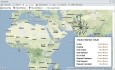
Geo Mapping
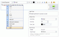
Website Chat Software v.1.2
Website Chat software allows IT managers of an organization to interact with existing and prospective buyers through web based chat sessions. It is offered in Web and Standalone versions.
Web Site Chat Software v.1.7
Providing the satisfactory resolution to the queries of website visitors is the best way to convert site visitors them into future customers. eAssistance Pro is reliable web site chat software which offers you various advanced features.

Web Chat Software v.1.2
Web chat software facilitates 24/7 chat services on the website. It cater specific chat requirements of organizations and monitor web access history, geographical location and time of the website visitor.

Add Live Chat On Website v.1.7
Adding effective live chat software into website is very essential because it offers a dynamic and quick platform to visitors to get instant solution of their queries.
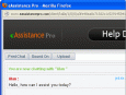
Live Chat Program for Websites v.1.7
Few features that make this live chat software different among others available in the market nowadays are live chat, spell checker, visitor monitoring, secure & reliable, geo mapping, fully customizable, traffic stats, multi-lingual support, etc.
IP-Country mapping Database v.1 2
Where are your Internet visitors coming from? IP Address Country mapping Database can help you identify visitor's geographical location of an IP address. The IP Address to Country Code Database can be used for: 1>Real Time Geo-Locating (

Geo Data German Admin v.15.00
The database contain geodata of the Federal Republic of Germany with geo referenced towns, municipalities, town quarters, administrative units, postal codes, telephone preselections, nature areas, landscapes, climatic zones for proximity searches ec.
Macrobject DObject O/R Mapping Suite
Macrobject DObject suite is an O/R Mapping (Object-Relation Mapping) component package to be used in Borland Delphi. DObject O/R Mapping suite supports a variety of databases and transparent to users and needn't to alter code when switching to different

Geo Data Germany v.15.02
The database contain geodata of the Federal Republic of Germany with geo referenced towns, municipalities, town quarters, administrative units, postal codes, telephone preselections, nature areas, landscapes, climatic zones for proximity searches ec.
Eye4Software GPS Mapping Studio v.4.1
GPS Mapping Software for Windows, Loading topographic maps, Realtime navigation, GPS position tracking, Map import and export, Coordinate conversion and more
LimitState:GEO v.2.0.6
LimitState:GEO is the revolutionary geotechnical stability analysis software that can be used to rapidly determine the critical failure mechanism and margin of safety for any type of problem, including those involving: * slope stability * retain
Graham Process Mapping Professional v.7.10.0517
With the Graham Process Mapping Software and methodology, detailed process maps are easy to draw, easy to edit and easy to read. Eight basic process mapping symbols cover all aspects of work at the element level.